Pioneer Descendants Preserve History of the Hole in the Rock
Contributed By David Walton, Church News contributor
.jpg)
From the southwest “gate” to Bluff Fort, visitors can see the bluffs north of town.
Article Highlights
- Apostle Erastus Snow advised pioneers to consolidate their settlement in Bluff, Utah, into a central “fort” for protection.
- The rebuilt fort now has 13 full-time Church-service missionary couples, one single sister, and 21 local volunteer docents to staff and care for it.
The San Juan Cooperative has been the centerpiece for the fort at Bluff, Utah, for 135 years. This institution was among the first things established by the Mormon pioneers who settled here, arriving on the 50th anniversary of the organization of the Church, April 6, 1880.
Although their trek to the San Juan River was supposed to take six weeks, their arduous journey to the southeastern corner of Utah took six months. The journey included the frightening task of descending some 1,000 feet from a high plateau. By the end, the pioneers were nearly destitute.
Necessity required them to establish means of feeding their families. Under the leadership of Platte D. Lyman and Jens Nielson, they formed crews to harness the San Juan River and survey and establish lots and farms. Some went to Colorado for employment or community supplies. Apostle Erastus Snow advised them to consolidate their settlement into a central “fort” for protection from the Navajo, Ute, and Paiute peoples whose intersecting borders they now occupied.
Bluff’s residents worked as one, banding together for community protection. Work on the irrigation ditch and meetinghouse proceeded, and by June 1882 they formed the San Juan Co-op. It paid well from the first. They bought Navajo wool, pelts, and blankets to sell in Durango, Colorado, and returned with wagons of merchandise to sell. Trade became so profitable that each stockholder eagerly took his turn when it came time to make the trip. Local freighting and revenue from the store provided a way for the people to stay in San Juan long enough to make a start in the cattle business, which became their salvation.
However, their livestock business faced stiff competition from well-financed outside outfits. Bluff citizens merged their herds to form the “Bluff Pool” and bought out the competition. They used their new wealth to exchange cabins for stone homes. A rock church replaced the log meetinghouse. They built a stone schoolhouse and replaced the original log co-op with a two-story stone edifice.
A gold rush and oil boom brought in hundreds of new people during the late 1890s and early 1900s. Many found lodging in Bluff homes; others found shelter in cabins abandoned when the original residents moved to more suitable farmland at Verdure, Monticello, and Grayson (Blanding). The co-op’s clientele changed somewhat, but its role remained intact as the town’s pioneer residents dwindled away to just nine of the first families.
In 1925, Fred Starr (alias) tried to rob the co-op by blasting open the safe. However, he used too much dynamite, which caused the demise of both the co-op store and Fred Starr.
Bishop Jens Nielson’s great-granddaughter Corinne Nielson Roring began to fulfill a lifelong dream of her father’s (Floyd Nielson), which was to rebuild the old fort where he was raised. In 1994 she purchased the property where the original Barton cabin still stands. It was preserved and restored. Grant Taylor and Lamont Crabtree joined her team, and they purchased the Kumen Jones property; the log meetinghouse was rebuilt. A few years later, Karl and LaRue Barton purchased the rock home in Bluff built by her great-grandfather Jens Nielson.
A memorial wall to the original Hole in the Rock pioneers was planned, installed, and dedicated in 2004 by then-Presiding Bishop H. David Burton. After much more work, the majority of the “square” was acquired, a visitors’ center was opened, and plans were made for reconstruction of the co-op store. The Hole in the Rock Foundation was formalized in 2006, and the co-op building was completed in 2013.
The fort now has 13 full-time Church-service missionary couples, one single sister, and 21 local volunteer docents to staff and care for it. Through their service they help educate and inspire visitors from all around the world.
Preserving and sharing the Hole in the Rock story has been a dream of many Bluff pioneer descendants for years. Corinne Roring, former president of the Hole in the Rock Foundation, said, “When the time is right, it will happen.” It’s happening.
.jpg)
A photo of the current town of Bluff showcases the geographical feature for which it was named. Photo by Kay Shumway.
.jpg)
Cow Canyon on the northeast edge of Bluff. Pioneers used this canyon to get onto the surrounding mesas. Photo by Kay Shumway.
.jpg)
One of the restored pioneer homes in Bluff, Utah. When the original settlers moved from the fort and built better homes, they used stone from the surrounding area. Photo by Kay Shumway.
.jpg)
A recent aerial photo from a quadcopter of the Bluff Fort shows cabins built by pioneer descendants, the rebuilt store, the old original Barton cabin, the remains of the Kumen Jones stone home, and other structures. Photo by Kay Shumway.
.jpg)
The rebuilt Bluff Co-op store and Bluff Fort Visitors’ Center welcomes thousands of visitors each year. Photo by David L. Walton.
.jpg)
The log meetinghouse and visitors’ center seen through the remains of the Kumen Jones cabin. Photo by David L. Walton.
.jpg)
Mule’s Ear rock formation along the San Juan River near Bluff, Utah, shows the rugged terrain faced by early pioneer settlers. Photo by David L. Walton.

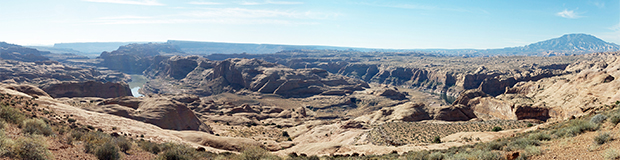
A view of Bluff, Utah, looking west. The San Juan River flows left to right against the far bluffs. Photo by David L. Walton.
.jpg)
The Hole in the Rock (left), a natural crevasse in the Colorado River gorge, was widened by pioneer settlers to allow wagons to pass down to the “slantendicular” cliff that had to be crossed before reaching the river 1,800 feet below. Photo by David L. Walton.
.jpg)
A photo of the bluffs north of Bluff, Utah, shows Locomotive Rock on the left and Calf Canyon right of center. Calf Canyon was used as a natural corral during the early years of settlement. Photo by David L. Walton.
A photo of the San Juan River gorge viewed from Grey Mesa (a major obstacle) along the Hole in the Rock Trail. Photo by David L. Walton.