“The Exodus: Israel’s Wanderings in the Wilderness,” Ensign, Mar. 1990, 42
Old Testament
The Exodus:
Israel’s Wanderings in the Wilderness
For four hundred years, Jacob’s descendants languished in bondage until the Lord provided them with a deliverer, the prophet Moses. True to his promise to Jacob (see Gen. 46:2–4; Gen. 50:24–25), the Lord brought Jacob’s posterity out of Egypt with unimaginable power and renewed his covenant with them in the Sinai Desert. But the children of Israel’s rebelliousness prevented them from inheriting the promised land then. For forty years, they stayed in the wilderness, until Joshua took the next generation into the Holy Land. The following photographs show places where the children of Israel sojourned during the Exodus.
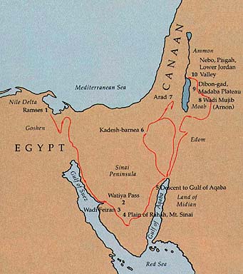
1. Making mud bricks with straw, Nile delta. For centuries, the technique pictured here of making bricks has changed little. Straw is mixed with mud from the Nile and placed in forms. The forms are emptied onto the ground, where the sun dries the mixture. The Egyptians required the enslaved Israelites to make bricks. (See Ex. 1:14; Ex. 5:6–19.)
2. Watiya Pass. The granite mountains and gorges of southern Sinai would be impassable but for the wadis—dry riverbeds (called highways of the desert)—that cut through them. This photograph shows a typical pass through the rocky terrain. The children of Israel would have used passes like these to travel through the desert.
3. Wadi Feiran: Oasis. The runoff of snow from Sinai’s high mountains has created several large oases, the most prominent of which is the Wadi Feiran, pictured in these two photographs. The oasis offers more than six miles of trees and wells. Few wadis cross the entire Sinai, but this wadi is an exception. Joining with two other wadis, it offers one of the few single routes from the Gulf of Suez to the Gulf of Aqaba. The children of Israel may have used this wadi because it begins by the traditional site for Mount Sinai. Many scholars identify the wadi with biblical Rephidim. (See Ex. 17:1; Ex. 19:2.) At Rephidim, the Israelites fought with Amalek. They prevailed as long as Moses held up his hands, so Aaron and Hur supported his arms until complete victory was achieved. (See Ex. 17:8–13.)
4. Plain of Rahah and Mt. Sinai. Jebel Musa (7,486 feet above sea level), in the distance to the left, is the traditional Mt. Sinai (also called Horeb), which the children of Israel reached three months after escaping from Egypt. (See Ex. 19:1–2.) Moses was reunited with his family there. (See Ex. 18:1–6.) Years earlier, he had seen on that mountain the bush that burned but was not consumed. (See Ex. 3:1–6.) During the Israelite encampment there, Moses talked with God and received the Ten Commandments. (See Ex. 19:3–20:17.) No wonder the Old Testament called Mt. Sinai “the mount of God.” (Ex. 18:5.) In the photograph, the plain before the mountains is the traditional site where the children of Israel made and worshipped the golden calf. (See Ex. 32.) They also built the Tabernacle there. (See Ex. 31:1–11; Ex. 36:1–38.)
5. Descent to the Gulf of Aqaba. In the distance lies the Gulf of Aqaba on the Red Sea, and behind it the mountains of Midian, which was the land of Jethro, Moses’ father-in-law. At the Red Sea, the children of Israel complained of having only manna and no flesh to eat, and they longed for Egypt. A wind from the Lord brought quails across the water. Forty years later, the Israelites returned to the Red Sea, then turned northward to enter the land of Canaan from the east side of the Jordan River. (See Num. 21:4–35.)
6. Kadesh-barnea: Oasis. In northern Paran, bordering the Negev Desert and the Wilderness of Zin, is a spring that waters the wadi system shown in the photograph. The surrounding area is desolate, but the oasis is large and fertile. Called Kadesh or Kadesh-barnea, it became Israel’s base camp. From Kadesh, Moses sent twelve men to spy out the land of Canaan. They returned with an “evil report” of how strong the inhabitants were. (See Num. 13.) The Israelites revolted and decided to return to Egypt, but they ended up remaining at Kadesh for forty years. The Lord declared that, because of their rebelliousness, they would not see the promised land. Instead, their children would inherit it. (See Num. 14:1–39.) Near Kadesh, Moses also smote the rock so that water would spring forth. (See Num. 20:2–13.) Miriam, Aaron’s sister, died at Kadesh. (See Num. 20:1.)
7. Ancient Arad (restored). When the Israelites heard that they would not inherit the promised land in their generation, they determined to try to take it anyway, even against Moses’ counsel. Passing through the wilderness of Zin, they fought the Amalekites and Canaanites at Hormah and Arad and were soundly beaten. (See Num. 14:39–45.) Arad offered the most direct route to Canaan. Nearly forty years later, they defeated the king of Arad but still had to return to the Red Sea and approach Canaan east of the Salt Sea. (See Num. 21:1–4.)
8. Wadi Mujib (biblical Arnon) and the King’s Highway. This great divide is the biblical Arnon. Both sides originally belonged to Moab, but the Amorites took all the land of Moab north of the Arnon River, above the canyon in the picture. (See Num. 21:26.) The children of Israel conquered the Amorites, and Arnon became the boundary between Israel and Moab. (See Num. 21:21–25.) The road leading from lower left to center right marks where the King’s Highway used to run. The highway was the main caravan route from Arabia.
9. Dibon-gad and the Madaba Plateau. The Madaba Plateau, to the right of the Arnon River in the center, stretches north for thirty-five miles. Israel camped at Dibon-gad, center right. (See Num. 33:45–46.)
10. Nebo, Pisgah, and the Lower Jordan Valley. Mount Nebo and Mount Pisgah may be the same. In the photograph, Mount Nebo is the built-upon hill on the mountains just to the right and above the center. The Jordan Valley is in the upper left, with the mountains of Ephraim and Judah barely visible behind. Balak took Balaam to three different spots to view Israel, trying to convince Balaam to curse the nation. Each time, Balaam blessed them. One of the spots was the top of Mount Pisgah. (See Num. 22:41–24:25.) The Lord later commanded Moses to climb to the summit of Mount Nebo. There, he showed Moses all the land he had promised Abraham. But Moses was not called to enter the promised land. Though the Old Testament says that Moses died on the mountain, it also says no one knows of his sepulchre. The Book of Mormon relates that Moses was really translated. (See Num. 27:12–14; Deut. 32:49–52; Deut. 34:1–6; Alma 45:19.)
Photography by Richard Cleave. Used by permission.