“Beyond Temple Square: A Walking Tour of Old Salt Lake,” New Era, May 1973, 6
Beyond Temple Square:
A Walking Tour of Old Salt Lake
The great bronze image of President Brigham Young, standing at the intersection of South Temple and Main Streets in Salt Lake City, has meant many things to many people. To me it always seemed that Brother Brigham was pointing to the location of the confectionary and bakery shops of ZCMI, where ice cream cones, stick candy, and warm bread, baked the old-fashioned way in a cast iron stove, dripping with melting butter and runny honey, could be had.
Salt Lake City has always meant more to me than the stores, the hotels, the restaurants, and the ever-increasing traffic. Salt Lake has meant shopping trips, family reunions, and general conference. It’s been the excitement of wandering through Temple Square as I imagined men on rough scaffolds struggling to place the statue of the angel Moroni on the top spire of the temple. It’s been the feeling of a hard-earned quarter clutched tightly in my hand as I stood in ZCMI, awestruck that one store could have so many treasures. For me, at least, the pioneer objective had been realized. Salt Lake City was the center of the whole world.
Now I go to Salt Lake City more often, but it is still the big city. It’s different from Los Angeles or Chicago. Sure, Salt Lake has smog now. It has urban blight and parking problems, but still it is different.
It’s different because of the history that took place behind that statue of Brigham Young. Maybe Brother Brigham is standing there like a master of ceremonies introducing his personally selected cast of historical characters and events.
The story of the city usually begins in July of 1847 when Brigham Young rose from his sickbed in a covered wagon at the head of Emigration Canyon, looked down into the valley, and pronounced, “This is the right place.” The Saints wound their way down into the valley, knelt in prayers of thanksgiving, and began to plow the land. They built a bowery where they held religious meetings, and Brigham Young, using his walking stick as a pointer, staked out the ten-acre location of the Temple and its grounds. He made the dimensions the same as those which, according to Josephus, enclosed Herod’s temple in Jerusalem. Then he plotted the rest of the city into large lots on ten-acre blocks. He staked out streets wide enough that a team of oxen could turn around in them.
Brigham Young established his own homestead on the block east of Temple Square. There he built two houses to accommodate twelve of his wives, their children, and the hired help. Simultaneously, businesses were established, a Council Hall was built, and an irrigation system was constructed.
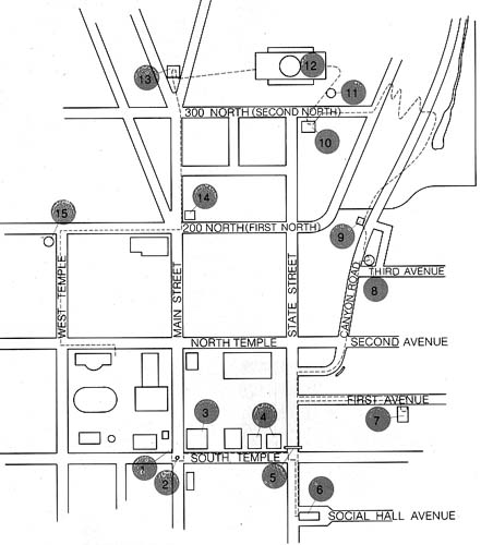
Although some of these early landmarks have given way to progress, there are still a number of historic sites that are preserved, many within walking distance of the Temple grounds.
Begin your tour at the southeast corner of Temple Square at South Temple and Main Streets, marked (1) on your map. There, enclosed behind a wrought-iron fence, is the stone obelisk placed by Orson Pratt, member of the Council of the Twelve under Brigham Young, to mark the base and meridian lines. It is incorrectly placed because Elder Pratt was unable to set his watch during the trek to Utah and guessed at the time of day when he made his calculations. But, nevertheless, it is the point that established the base and meridian lines for all future surveys in Utah. The official base and meridian stone set by the United States government is located fifty feet west, inside the Temple Square walls.
Now look out into the street. There, in the middle of the intersection, channeling traffic, is the Brigham Young Monument (2). This monument was erected in 1897 to celebrate the fiftieth anniversary of the founding of the city. It was sculpted by Cyrus E. Dallin to represent three epics in the habitation of the valley—the native Indian, the bearded mountain man, and on the top of the granite shaft, Brigham Young gesturing toward his valley.
The bank across the street, Zion’s First National Bank, represents one of Brigham Young’s many interests. He founded it, as well as ZCMI next door, to compete temporally with the gentiles. ZCMI (Zion’s Cooperative Mercantile Institution) opened its doors to the public in 1868 and has been successful ever since. At the present time a new store is in the process of construction, complete with a replica of the old cast-iron store front.
On the northeast corner of South Temple and Main Streets, across the street from where you are standing, is the Hotel Utah (3). It replaced the 2 1/2-story building that housed the Deseret News Publishing Company and the Deseret Store. The Press began publication in 1850—printing the first newspaper in the West. The printing press itself was laboriously carted across the plains in a wagon with one of the first parties of immigrants. The press was first used in the valley in 1850, and even then a paper was not published regularly.
Next door to the Deseret Publishing Company the Tithing Office and Store stretched to the north. Every devout Mormon paid one-tenth of his increase to the Church. Often payment was “in kind”—a cow, a sheep, a load of hay, or a sack of flour. Similarly, the Church paid its laborers and its debts with script redeemable for the “in kind” merchandise at the tithing store.
Continue your walk in early Salt Lake by continuing east on South Temple until you come to the Lion House (4), one of Brigham Young’s own homes. Constructed in 1855, it consisted of three floors. The basement floor housed the family work rooms, including the kitchen and dining rooms. The main floor accommodated the prayer room or parlor and private sitting rooms for the wives. The upstairs was devoted to sleeping rooms. Contrary to the rumors that continue to exist, the twenty dormer bedrooms on the second floor were not for the wives alone but also for the children and hired help. On the porch is the lion that gives the house its name; it is said to symbolize Brigham Young’s character. In fact, he was sometimes called the “Lion of the Lord.”
Next door, is the Beehive House where Brigham Young conducted his business and entertained his guests. I always thought that the Beehive House was well named, for it must have been a hive of industry. Each of the forty-some children had his own job to do—including pumping all the water from the one family pump for the two households, caring for the silk worms in the sheds behind the houses, and weeding the large vegetable and flower gardens.
Across State Street, east from the Lion and Beehive houses, stood the private school for the children. There was a pool of water outside at the rear of the school that became a natural baptismal font. At the corner was the Eagle Gate (5), a tollgate for the maintenance of the road through the farm and up City Creek Canyon. The cobbler for the Young household served double duty as the mender of shoes and the collector of tolls for the road. As the city grew, and the road up City Creek Canyon became a major thoroughfare, Eagle Gate was twice enlarged to make room for a wider street.
Detour one-half block south on State Street to Social Hall Avenue, the original site of the first theater west of the Missouri River (6). The old theater had a seating capacity of three hundred people, although four hundred people were often crowded into it. Constructed in 1852, Social Hall was used for more than fifty years for theatricals, dances, and other amusements.
Return to Eagle Gate and walk about a half block north on State Street, then east on First Avenue to the Brigham Young family cemetery plot (7). Here, at the end of a grassy slope, Brigham Young, three of his wives, and several of his children are buried beneath unpretentious stone slabs. (A later city ordinance prevented more burials in the family plot.)
Retrace your path back to State Street and walk north for about a block until you come to Canyon Road, the early toll road through President Young’s estate. About a block north on Canyon Road is a granite marker indicating the site of Salt Lake City’s first grist mill (8). During the first few years of the settlement, flour was in such demand that it sold for a dollar a pound while beef, relatively plentiful, was selling for ten cents a pound.
Another block north on Canyon Road is the Veteran Volunteer Fireman’s Hall (9). This dilapidated building still houses the first manually operated fire pump in the West.
As you walk beyond the Fireman’s Hall, you come to the entrance of Memory Grove, a city park where groves of trees were planted in 1920 to honor war veterans. This is a good place to rest in the shade, and if you feel inclined, to wiggle your toes in the clear stream that tumbles through the park. It was at this point that City Creek water was diverted downtown for irrigation purposes. It watered the city home plots as well as the acres of turnips, wheat, and potatoes growing on the farms in the valley. This marked the first use of irrigation by white men in the United States.
When you’re ready to face the upward trek, continue your walk by crossing the street, ascending the several flights of stone stairs leading west, and following the zig-zag path to the crest of the canyon and the state capitol grounds. At the top, about one-hundred yards west, is the sandstone reconstruction of the Council Hall (10). This was the first important public building constructed by the pioneers. When it was first built, it stood on First South east of State Street. It housed the offices for Utah’s first territorial government, city hall, police station, and health department. In 1961 it was carefully dismantled and rebuilt stone by stone at its present location. The rooms that have been refurnished are open to the public.
North, across the street, and east on the Capitol Building grounds is the Mormon Battalion Monument (11). This was dedicated in 1927 to the 536 Mormon pioneers who were called on missions by the Church to serve the United States Army in the Mexican War. These men marched two thousand miles from Nebraska to Sante Fe, New Mexico, and then to San Diego to secure the Southwest for the United States.
The State Capitol (12), a good place to cool off on a hot summer day, or to warm up on a cold winter day, was designed by Richard Kletting in 1915 to look like the national capitol. Inside the building you might be interested in Exhibition Hall, where each of the 29 counties of Utah have a glass-enclosed exhibit showing its scenic attractions.
West of the State Capitol building is the Daughters of the Utah Pioneers Memorial Museum (13). Modeled after the old Salt Lake Theater, the museum houses many artifacts of the pioneer period. Be sure to see the new carriage house that exhibits the wagon in which Brigham Young first rode into the valley in 1847. The Museum is free and open to the public Monday through Saturday.
As you return to Temple Square, walking downhill south on Main Street, you pass the once magnificent McCune home (14). The story is told that the wife of the original owner was serving as a guide on Temple Square when a haughty visitor asked her about the living conditions of the typical, uncouth Mormon. She assured him that she was an ordinary native and invited him to her “typical” home, with its marble floors, gold doorknobs, carved balustrades, and third-floor ballroom. The visitor was much astonished that this was the way Mormons lived!
This is a good place to pause for a look down over the valley. The building that dominates the scene is the new LDS Church Office Building. This building is twenty-eight stories high with an observation deck on the twenty-sixth floor. It brings together all of the administrative offices of the Church that were formerly scattered in buildings located all over the city.
Continuing down the hill you pass the Deseret Gymnasium, once the site of one of the first log cabins in Utah (the same log cabin now preserved in the southeast corner of Temple Square).
A little out of our way is a marker on a boulder on the corner of First North and West Temple (15). This marker indicates the site of the classes of the University of Deseret, now the University of Utah. The second law passed by the territorial government concerned the incorporation of this University, and the first classes were held here in March of 1850. Unfortunately, the territorial government failed to appropriate funds for the school, so its first teacher had to accept tuition composed of live chickens, barrels of molasses, baskets of fruit, etc.
Now you return to the fifteen foot high walls of Temple Square, but don’t give up yet. There is much more to see in historic Salt Lake City. Any person interested in capturing more flavor of the pioneer past will want to visit the reconstructed Pioneer Village Museum at 2998 South 2150 East, as well as This is the Place Monument in the Pioneer State Park at the mouth of Emigration Canyon. You will also be interested in seeing one of the two daily (except Sunday) performances of the musical Promised Valley. This free performance, held in an air-conditioned theater at 132 South State Street during July and August, portrays the events of the pioneer journey to the Salt Lake Valley.
5. At left, Eagle Gate, originally a tollgate, leading up to City Creek Canyon, has been remodeled twice
1. Above, top, the Great Salt Lake Base and Meridian Marker is the basis for all surveys of Utah and was set by Orson Pratt in 1847
3. Above, Hotel Utah, built in 1911, won the American Architectural Award for that year. The hotel stands on the location of the 2 1/2-story building that housed the Deseret Publishing Company and the Deseret Store
2. The Brigham Young Monument, erected in 1897, commemorates the fiftieth anniversary of the pioneers entering the Salt Lake Valley
9. Above, the Veteran Volunteer Fireman’s Hall houses the first piston-type water pump built in the West
7. At right, simple stone slabs mark the graves of Brigham Young and three of his wives. Several of his children are also buried in this small cemetery
4. At left, the Lion House, built in 1855, was one of Brigham Young’s homes. It housed the family work rooms, including the kitchen and dining room
14. Below, the McCune Mansion is a stately reminder of the opulent era around the turn of the century
6. Below, bottom, old Social Hall was the first theater west of the Missouri River. Constructed in 1852, it was the site of socials and dramatic productions
12. The Corinthian style of the Utah State Capitol is striking as the building stands boldly at the head of Salt Lake’s State Street. The structure was completed in 1916
13. The Daughters of the Utah Pioneers Museum, designed to appear like the old Salt Lake Theatre, houses many pioneer treasures
11. The Mormon Battalion Monument was erected in 1927 to perpetuate the memory of the pioneer men who served in the Mexican War of 1846
10. Council Hall, where Utah Government was housed in its infancy, has been restored to its former glory