“The Mormon Battalion March, 1846–47,” Ensign, July 1979, 57
The Mormon Battalion March, 1846–47
What has been called the longest infantry march in history—approximately 1,850 miles—began 20 July 1846 on the Little Pony River in Council Bluffs, Iowa. During the Mexican War of 1846 James K. Polk, president of the United States, requested five hundred Mormon men to help in the war effort.
Mormon leaders agreed: in addition to demonstrating their basic loyalty, Mormons would benefit from the military pay, the arms which the men could keep, the allotment for uniforms (since the Mormons were allowed to wear their own clothes), and being transported west at government expense.
On July 20 the battalion commenced a 180-mile march down the left bank of the Missouri for Fort Leavenworth, Kansas. While no Mormon was killed in the venture, two died enroute. The first, Samuel Boly, expired only twenty-eight miles from Council Bluffs.
The first part of this trail hugged the river bluffs. (It is interesting that all of the roads the Mormons used along the Illinois, Mississippi, and Missouri rivers followed the bluff line closely, for in those days of frequent flooding, roads were never built on the flood plain.) Today, the closer to the bluffs, the closer to the old roads. These bluff roads still exist, but one can get a good view of the area on Interstate 29 as far as Mound City, Missouri.
The men soon crossed the Nishnabotna River and entered Missouri from which they had been driven in 1838–39. They remained on guard, but suffered no difficulties from Missourians. Their first camp in Missouri was near Linden, a community of which little exists today save a graveyard. (Ask locally for directions.)
Next they passed through Mound City and Oregon, named after the famous trail. A marker on the courthouse square mentions the Mormons’ passage. The largest Missouri community on the battalion route was Saint Joseph and to impress the Missourians, they marched double file with music, astonishing many who had not believed the Mormons would answer their country’s call. Later Saint Joseph became the beginning of the Pony Express Trail.
The only part of this section of the march which still appears as it would have in 1846 is a back country road from Weston to Beverly. (Ask locally for directions.) On 1 August the battalion crossed the Missouri by ferry directly opposite Fort Leavenworth, which had been built in 1827 to help regulate western migration, Indian affairs, and the fur trade.
The Mormons left the fort August 13 marching southwest. They crossed the Oregon Trail west of Eudora, Kansas, and intersected the Santa Fe trail near the crossing of Highways 59 and 56. They followed this trail all the way to Santa Fe.
On August 27 they reached Council Grove, one of the principal stops on the Santa Fe trail. Here Colonel James Allen, who had brought Polk’s request for the battalion to Brigham Young, died. The Mormons had liked Allen and held a memorial service for him.
Between Council Grove and today’s Durham, trail ruts are still visible. Near Lyons, the men first sighted buffalo. At the famous Great Bend on the Arkansas River, they picked up the river trail and followed it to Ingalls in Gray County. Soon after reaching the Arkansas they sighted Pawnee Rock to the northwest, a famous landmark on the trail.
Francis Parkman, a famous historian, noted meeting the battalion near Larned, Kansas. West of Larned on Highway 156 is the Santa Fe Center which has much information about this old trail; near Dodge City some wagon ruts are still visible.
At Ingalls the battalion crossed the Arkansas and marched towards the Cimarron River. At this crossing the first of three sick detachments, ten men and several families, were sent back along the Arkansas to Fort Pueblo to spend the winter. These three sick detachments met the Mississippi Saints at Fort Pueblo and, the following summer, collectively joined Brigham Young and the pioneers at Fort Laramie.
From Ingalls into New Mexico the old trail cannot be followed closely by automobile. Ruts and markers, however, can be seen near Keyes and Boise City, Oklahoma, and Grenville, New Mexico.
Near Springer, Interstate 25 follows the old trail closely all the way to Santa Fe. Along this interstate, travelers can see Wagon Mound, another well-known landmark, some ruts, and several trail markers.
Santa Fe, founded about 1609 and the oldest seat of government of all state capitals in the United States, is well worth a visit. The advance companies of the battalion reached Santa Fe the evening of October 9 and camped in a wheat field back of the cathedral. They had by then marched nearly eight hundred miles from Fort Leavenworth and nearly one thousand from Council Bluffs.
Ten days later, the men were on the march again. Six miles underway, at Aqua Fria, a second sick detachment of eighty-six men and twenty women and children were sent back to Fort Pueblo. The reduced battalion, then consisting of 397 men, followed the old Spanish Trail southwards along the Rio Grande, passing a line of Spanish communities strung along the river. Interstate 25 follows the trail closely through old Albuquerque, now the largest city in New Mexico, passing Elephant Butte just inside Sierra County, to Truth or Consequences. Three miles west of here, on November 9 and 10, the third and final sick detachment of fifty-eight men was sent back to Fort Pueblo, leaving 339 trail-hardened men.
Shortly afterwards, near Hatch, the battalion left the Rio Grande and followed other Spanish trails—some vague, some established—towards the continental divide near the Arizona border. Enroute the Mormons were excited to find petroglyphs thirteen miles north of Deming in Cook’s Canyon, considering them circumstantial evidence of the Book of Mormon. Visitors will find it difficult to visit Cook’s Canyon today, even by ranch roads. (Ask locally for directions.) Ruts of the old Butterfield Stage road are visible through this canyon. There is also a trail marker out of Deming on Highway 180. From Deming, several roads, none following the trail, lead to Arizona. The most scenic is through the Coronado National Forest.
Just inside Arizona the old trail dipped into Mexico and picked up the San Pedro River near Naco. Along this leg of the trail the second Latter-day Saint died, Elisha Smith.
On December 11 the battalion fought its only engagement of the Mexican War—one with wild bulls. One man was gored in the leg and sixty to eighty bulls were killed. A marker on a road southwest of Charleston describes this event.
From the San Pedro River the battalion passed through Tucson and headed for the Gila River along which, north of Theba, they saw more Indian petroglyphs at what is today’s Painted Rock State Park. Several days later they crossed the Colorado River near Yuma and entered present-day California.
Their journey was nearing an end, but first they had to cross the dreadful Imperial Desert in Mexico between the Colorado River and today’s Mexicali. Along here, roads do not stay close to the original trail, but after Ocotillo, Highway S2 generally parallels the trail.
They entered Box Canyon northwest of Ocotillo which in parts was a foot narrower than their wagons. Places where the Mormons had to cut through the canyons are still visible. After this, the battalion rested at Warner’s Ranch.
Following various small rivers they passed the famous San Louis Rey Mission, one of the twenty-one Spanish Missions founded in California. Thereafter they marched along El Camino Real, the Royal Road, connecting these missions, to their destination at Mission San Diego where they arrived January 29, 1847. They established themselves one mile below the mission and about five miles from General Stephen W. Kearney’s military headquarters on the sea. Here a large statue of a battalion member can be seen.
The battalion filled its enlistment term with performed routine garrison duty in San Diego, San Louis Rey, and Los Angeles, until being discharged 16 July 1847. Some reenlisted for six months, but most made preparation for joining the pioneers in the Great Basin. They pushed north and picked up the Old California Trail east of San Francisco. Some decided to winter at Sutter’s Fort—and were present when gold was discovered in January 1848. Those who had gone on arrived in Salt Lake Valley 16 October 1847.

Mormon Battalion Trail, 1846–47 Iowa
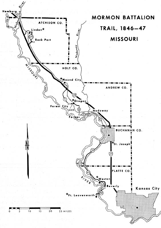
Mormon Battalion Trail, 1846–47 Missouri
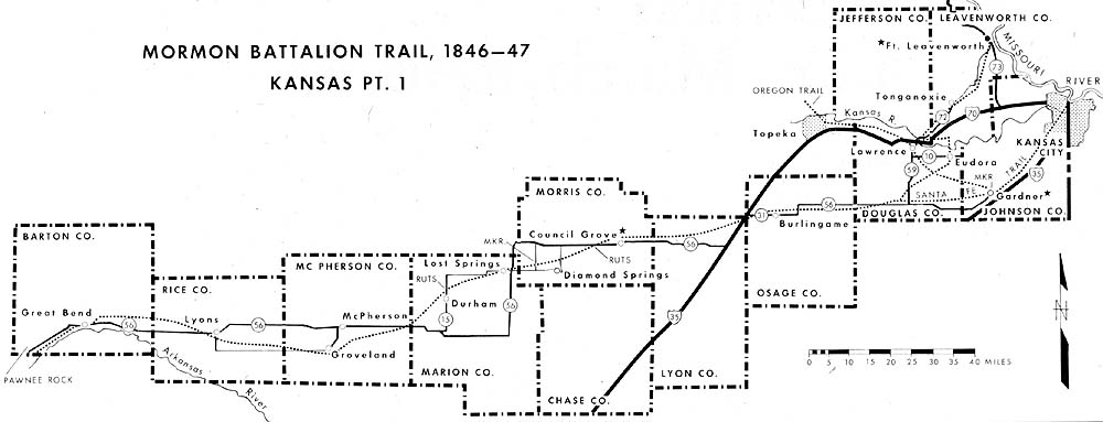
Mormon Battalion Trail, 1846–47 Kansas Pt. 1

Mormon Battalion Trail, 1846–47 Kansas Pt. 2, Colorado, and Oklahoma
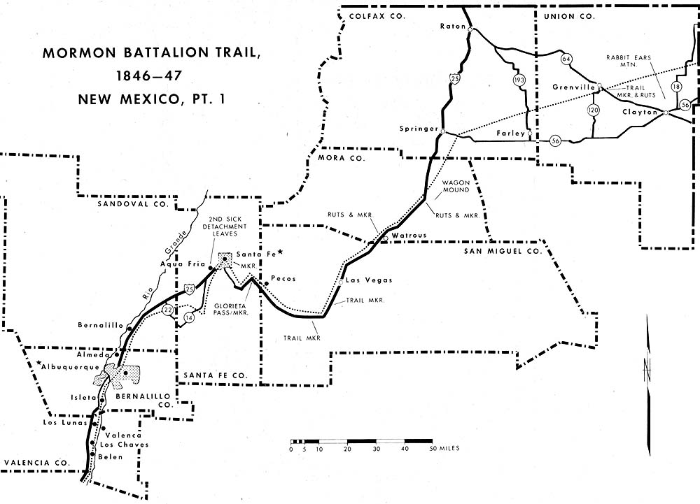
Mormon Battalion Trail, 1846–47 New Mexico, Pt. 1
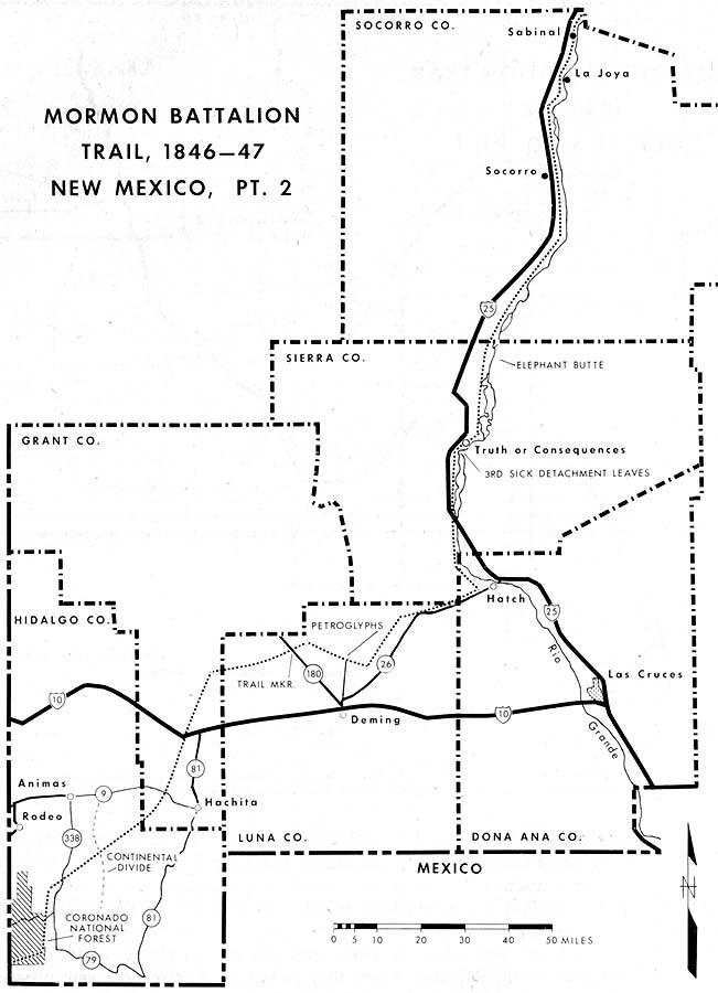
Mormon Battalion Trail, 1846–47 New Mexico, Pt. 2
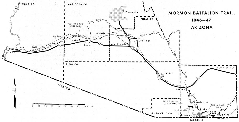
Mormon Battalion Trail, 1846–47 Arizona

Mormon Battalion Trail, 1846–47 California